

Journal of Creation 34(3):109–117, December 2020
Browse our latest digital issue Subscribe
Land bridges after the Flood
Biogeography is a difficult subject. Uniformitarian scientists once thought they had the answers with the vicariance hypothesis, but they recently encountered numerous contradictions. Many now support vegetation rafting as a more plausible theory. In the Creation-Flood model, thick log mats left over from the Flood would aid animal dispersal in some cases, but most animals likely made use of land bridges. Two land bridges are discussed in this paper. First, there was a land bridge across the Dover Strait connecting the English Channel, which allowed hippos to migrate into the United Kingdom. Second, the Bering Land Bridge between Russia and Alaska that likely was tectonically raised early in the Ice Age.

Biogeography, the study of the geographic distribution of plants and animals around the world, is a difficult subject for both uniformitarian and creation scientists. There are many perplexing observations of present-day and Ice Age distributions of animal and plants. These give rise to many questions, including how marsupials arrived in Australia and South America, and how the now extinct, large mammals arrived in South and Central America.
Uniformitarian scientists cannot explain biogeography
In the 1960s and 1970s, biogeographers believed that plate tectonics would resolve biogeographic puzzles. They assumed that plants and animals first evolved on a supercontinent comprising one land mass, and as this broke up and drifted apart the animals and plants ‘rode the plates’ to their present locations. They thought subsequent evolution of the organisms would explain their present differences on different continents. This is called the vicariance hypothesis because plants and animals were passively or vicariously transported on the diverging plates.
This theory has suffered in the face of overwhelming opposing evidence1,2 in DNA comparisons and fossils.3,4 There are reasons to be suspicious of these fossil comparisons, a subject that is part of cladistics.5 However, some scientists are convinced the method itself is flawed.6,7 And the molecular data are calibrated with reference to evolutionary interpretation of the geologic and fossil record,8,9 so an old-age bias is built into the methodology. Regardless of whether these methods are reliable, uniformitarian scientists concluded that many plants and animals did not arrive on the separated continents or oceanic islands until well after the break-up of the supercontinent.10,11 This implies that the plants and animals had to transverse water, and in some cases oceans.12 Although many anomalies are leading scientists to reject the vicariance hypothesis as the primary explanation for biogeographic distributions, dispersion by rafting is gaining ground.13 Cowie and Holland summarized:
“We hope, therefore, that the trend identified by de Queiroz (2005)—the resurrection of oceanic dispersal as important in historical biogeography—is real and that the straightjacket of strict vicariance biogeography is being loosened to include once again the plurality of mechanisms and processes that make evolutionary biology the exasperating but ever fascinating discipline that it is.”14
Evolutionists are left with three main mechanisms: (1) connections by now submerged land bridges; (2) island hopping across a series of adjacent islands, if close together; and (3) rafting on vegetation, sometimes across vast oceans.15 Land bridges and island hopping have not become popular ideas, though the Bering Land Bridge is an exception. As a result, many scientists have no choice but to opt for the third option, rafting dispersal, despite it being considered impossible a few decades ago. After all, they abhor a theoretical vacuum.
There have been several recent observations of successful rafting of lizards on pieces of floating vegetation after storms, giving support for rafting. When a hurricane ripped up vegetation on Caribbean islands, some lizards survived on vegetation rafts, and colonized other islands in the area.16,17 They were rafted only a few hundred kilometres. So, this is a rather trivial example, since it is doubtful these tiny rafts could have crossed an ocean.

Biogeographers have concluded that amphibians like frogs, found on Madagascar and other Indian Ocean Islands, must have been rafted to these islands several times despite being unable to tolerate saltwater.18 Likewise, they think that New World Monkeys (figure 1) were carried from Africa to South America on vegetation rafts.19 They are likely correct, but the rafts were far larger after the Flood, making the rafting hypothesis much more plausible in a Flood model.
Creation science challenges
Creation scientists need to explain how air-breathing land animals dispersed from the Ark after the Flood and arrived at far-flung locations. It is controversial whether Paleogene and Neogene animals are post-Flood,20-22 or from the Flood. I generally favour the latter, though there are exceptions. For the latter option, we need to explain the present and Ice Age distribution of animals and plants. We need to consider the many extinct Ice Age mammals. After the Ice Age, 66% of Ice Age mammals over 44 kg went extinct or disappeared from a continent at the end of the post-Flood Ice Age.23,24 Many birds and some reptiles also went extinct during this period.25,26 Table 1 shows the extinctions of mammals on each continent.
Table 1. Percentage of mammalian megafauna over 44 kg (100 lb) that went extinct during and around the late Pleistocene.27,28 Southern Eurasia is not included because of insufficient data

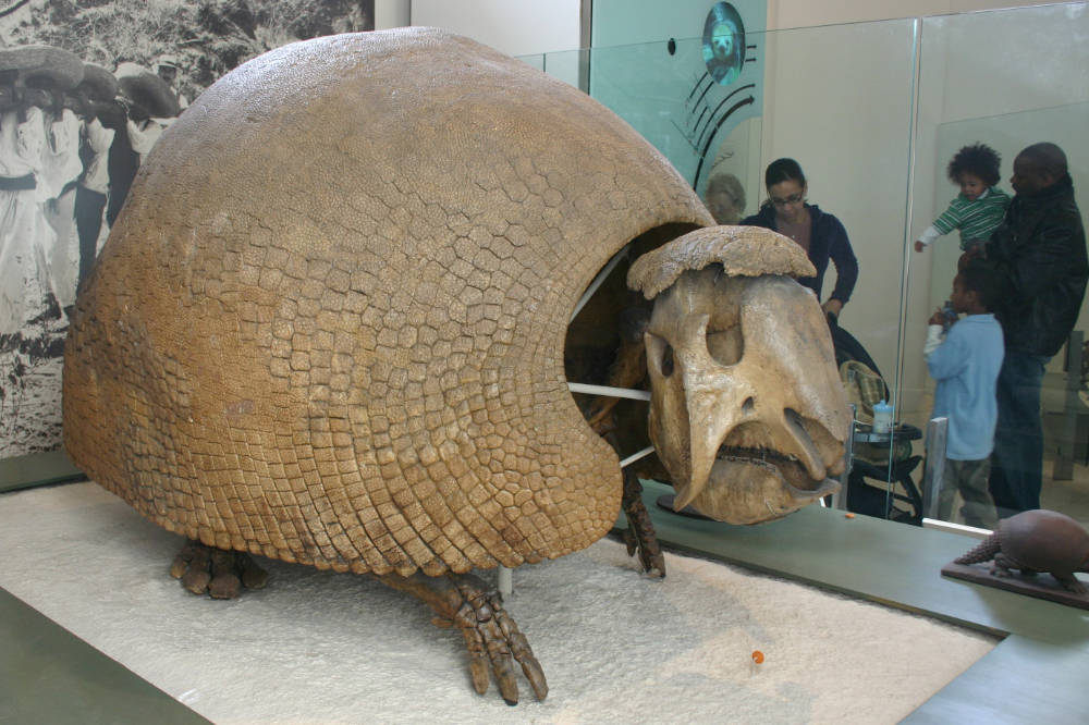
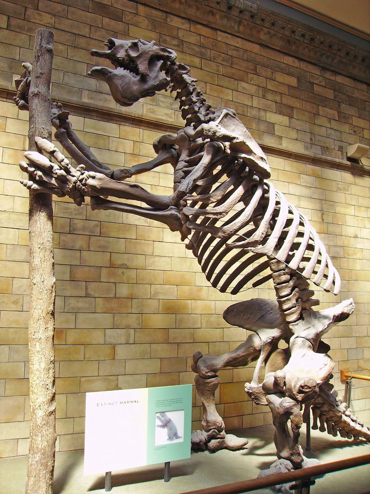
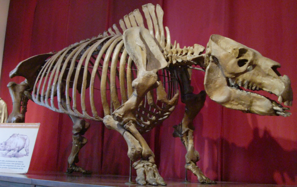
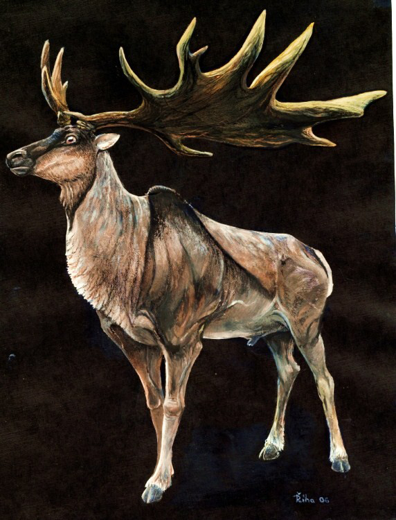
The non-glaciated areas during the Ice Age have been described as similar with respect to the variety and number of animals to the Serengeti of Africa.29 The large mammals living on non-glaciated areas during the Ice Age include the woolly and Columbian mammoths; American mastodons; various types of huge ground sloths (figure 2); sabre-tooth tigers; cave bears; diprotodons (figure 3); toxodons (figure 4); glyptodons (figure 5); and the so-called Irish elk, which was actually a giant deer (figure 6). We know that toxodons, a large hippo type animal 1.5 m tall with heavy rhinoceros-like body, weighed up to 1,415 kg. They lived in South America during the Ice Age. Arrowheads were found with a few of the toxodon skeletons, indicating post-Flood humans lived alongside of them near the end of the Ice Age.30 Glyptodons, a strange armadillo-like creature the size of a Volkswagen Beetle weighing up to 2,000 kg, lived mostly in South America. Some South American mammals survive to the present day, including the New World monkeys, tree sloths, and armadillos.
Dispersal on log mats
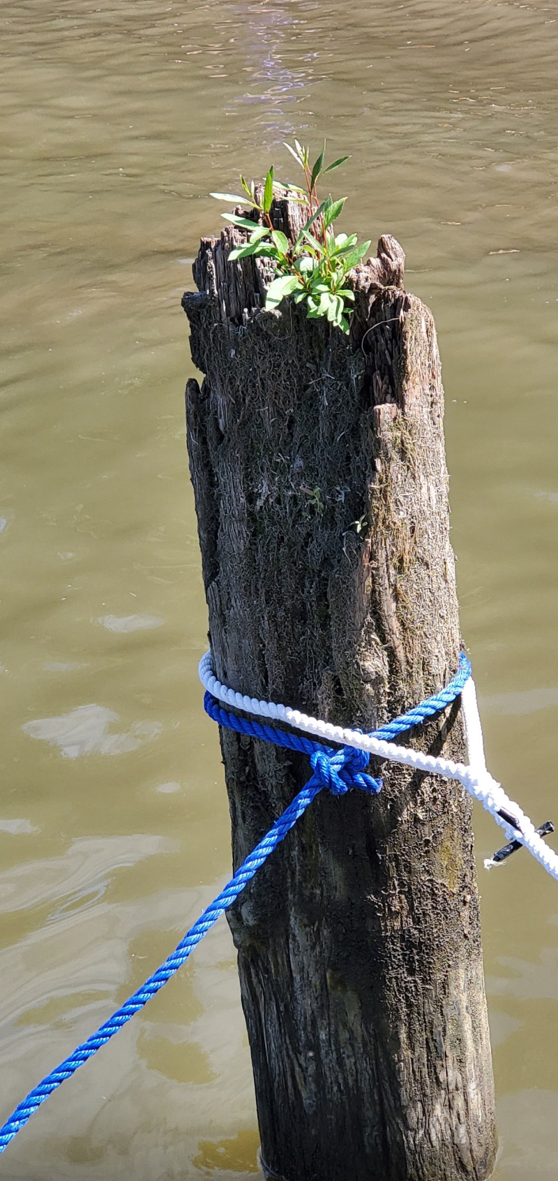
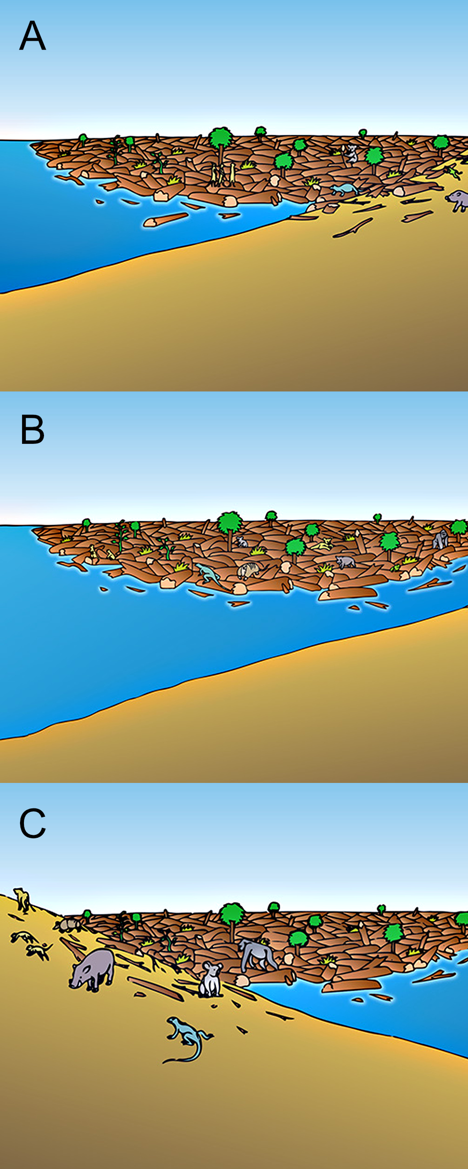
Log mats or possibly very large pumice rafts can explain some of the perplexing biogeographic observations.31 I mentioned back in 1995 that these could aid post-Flood dispersion: “Another application [of the log mat model] is that some of the floating debris likely survived the Flood.”32 Millions of logs of various sizes likely floated on the oceans for a few hundred years after the Flood.33,34 Even in recent times scientists have reported floating ‘islands’ of vegetation far from land, often with standing trees and mammalian inhabitants.35 Trees can even grow from logs (figure 7). If floating islands exist today after a storm, it stands to reason that a global Flood would create far larger islands. Wood and Murray believe that these log mats would have been thick enough and massive enough to be capable of carrying even large animals.36
There is indirect evidence that relatively large mammals were transported across open waters on post-Flood log mats because ground sloths not only colonized South America but also the Caribbean Islands.37 Sloths in the Caribbean Islands were not nearly as large as the ground sloths in the Americas. The only reasonable way to transport ground sloths and other animals to the West Indies is by rafting.38
Transport would begin when a log mat beached, for instance at low tide. Animals would meander onto it. When the log mat resumed floating, possibly after a storm or the rising of the tide, currents would carry the animals to distant shores (figure 8). However, it is questionable that very large Ice Age mammals, like mammoths, could be transported long distances on log mats. The only alternative is dispersal by land bridges.
Dispersal across land bridges
One of the most effective ways to disperse to the farthest locations from the Ark would have been by land bridges. Three land bridges have been proposed: (1) the connection between continental Europe and England at the Dover Strait; (2) the connection between Asia and North America across the Bering Strait; and (3) the connection or near connection between South-east Asia and Australia. The first two will be discussed in this paper. The third land bridge does not seem plausible because of the many deep, wide ocean channels, but will be discussed further in another paper on the subject of the dispersal of the Australian marsupials.
The land bridge across the Dover Strait
A land bridge once existed across the Dover Strait connecting the United Kingdom with continental Europe early in the Ice Age.39 Sonar features of the bottom of the English Channel at and near Dover Strait,40 the closest approach of England and France, revealed features similar to the Channeled Scablands, the catastrophic deposition and erosion caused by the Lake Missoula flood in eastern Washington.41,42 Scientists concluded from this and other evidence that a large lake formed in the southern North Sea when the water was blocked by advancing ice in the central North Sea.43 In the biblical Ice Age model, after the Scandinavian and British-Irish Ice Sheets coalesced the lake would have overtopped the land bridge and destroyed it.
This temporary land bridge surrounded by warm ocean water allowed many animals, including some warmth-loving mammals, to migrate to the United Kingdom early in the Ice Age. Probably the most surprising migrants were hippopotamuses that are found alongside reindeer, musk oxen, and woolly mammoths in England, France, and Germany during the Ice Age.44,45 Over 100 locations with hippopotamus fossils are found in England alone.46 Sutcliffe states:
“Finding conditions so favourable the hippopotamus (today an inhabitant of the equatorial regions) had been able to spread northwards throughout most of England and Wales, up to an altitude of 400 meters [1,300 ft] on the now bleak Yorkshire moors.”47
Hippos are intolerant of the cold.48 The current and historical range of hippos is almost entirely in sub-Sahara Africa. Severing of the land bridge trapped the animals in the United Kingdom. As the Ice Age advanced, animals that require at least a fairly warm environment to survive died together with many large cold-tolerant mammals.
Hippos from interglacials?
Uniformitarian scientists are perplexed by the numerous hippo fossils that lived in England during the Ice Age. They attempt to explain these by arguing that the hippos lived during an interglacial and the cold-tolerant animals in a glacial phase:49
“A number of faunal remains have been referred to the Eemian [the ‘previous interglacial’] because of the ‘interglacial’ character of the fauna; solid independent evidence for an Eemian age is, however, sometimes missing.” 50
Without dates and evidence, they automatically pigeonhole the fauna into interglacial and glacial slots based on their climate preferences. When scientists do this, they miss important clues about the real character of the Ice Age.
Stuart believes that during the ‘last’ interglacial of the late Pleistocene, the Eemian, hippos spread from the Mediterranean region west into France and north up into England.51 They then disappeared from England supposedly before the last ice age.
Scientists believe we are living in an interglacial, the Holocene. Interestingly, hippos do not live in Europe, the Mediterranean area, or the Middle East today except in protected, artificially warmed zoos. Although the previous interglacial is considered to have been warmer than the Holocene, it is doubtful that hippos would have survived the cool, wet winter climate of England.
Grayson informs us that scientists cannot pigeonhole fossils into interglacials and glacials because the animals are often found together in Ice Age sediments:
“In the valley of the Thames [southern England], for instance, woolly mammoths, woolly rhinoceros, musk ox, reindeer (Rangifer tarandus), hippopotamus (Hippopotamus amphibious), and cave lion (Felis leo spelaea) had all been found by 1855 in stratigraphic [sedimentary] contexts that seemed to indicate contemporaneity.”52
Mixing to enter glacial sediments?
Some scientists suggest that mixing and reworking of glacial and interglacial sediments can explain why hippo fossils are found in the same sediment as those of cold-tolerant animals. However, this still assumes that the warmth-loving animals would want to migrate as far north as northern England during an ‘interglaical’. Nilsson states: “The occurrences of such taxa as hippopotamus that are closely adapted to warmth, may result from the reworking of older, interglacial deposits.”53 However, it is doubtful that evidence for reworking of the sediments really exists.54 Uniformitarian scientists desire to separate the fauna because of their adherence to long-age uniformitarian assumptions: cold animals prefer glacial climates and warmth-loving animals inhabited warm regions during interglacials. This makes sense in a uniformitarian model that has very cold glacial periods. There is strong evidence against mixing because ‘disharmonious associations’ are widespread during the Ice Age and disappear in post-Ice Age sediments.55
More evidence against reworking is that mixing itself, supposedly happening during the Ice Age, did not carry over into the present interglacial. Why would ‘mixing’ suddenly stop at the end of the Ice Age?
A mild, equable climate during the early Ice Age
The discovery that hippos lived together with cold-loving animals in northern England during the Ice Age indicates the Ice Age climate was quite different from the cold climate the uniformitarian model predicts. Grayson tells us:
“If the musk ox required cold, and the hippopotamus required warmth, and the stratigraphic evidence implied that they had coexisted, then a straightforward reading of all this information could imply that glacial climates had not, as most felt, been marked by severe winters, but had instead been equable.”56
Grayson, quoting from a mid-1800s scientist, further states in regard to the hippopotamus bones associated with cold-tolerant animals in north-west Europe:
“There must have been cooler summers for the reindeer and musk-ox; and on the other hand warmer winters for the hippopotamus and other species whose analogs are today found withdrawn toward the tropical regions.”56

As Grayson explains, an equable climate with little seasonal contrast can explain disharmonious associations. It had to have also been a mild climate because of the many warmth-loving mammals so far north (figure 9). How could a mild, equable climate occur in England? In uniformitarian thinking it is impossible.
The hippos in north-west Europe, as well as disharmonious associations in general, provide strong evidence against a uniformitarian Ice Age believed to have had much colder summers and winters at mid and high latitudes. Hippos in England as well as other worldwide disharmonious associations are strong evidence that at least part of the Ice Age climate was equable and mild.
The biblical Ice Age model explains the hippos in north-west Europe
The post-Flood climate model can explain why the hippopotamuses and cold-tolerant animals lived together in northwest Europe during the Ice Age. The predominantly westerly winds off of the much warmer Atlantic Ocean early in the Ice Age would create a warm, wet climate in north-west Europe. England’s summers and winters may have averaged about 25°C with much more precipitation than today. Hippos could have comfortably spread north-west from the ‘mountains of Ararat’ across the Dover Strait Land Bridge into the United Kingdom.
The post-Flood Ice Age climate was very dynamic. After a few hundred years, midway to late in the Ice Age, the ocean cooled so the temperatures over the land also became cooler.57,58 North-west Europe was increasingly more populated by cold-tolerant animals. Many hippos were able to tolerate some cooling. Glaciation began in the northern mountains of the UK (the Scottish Highlands) about midway into the Ice Age, and then spread into lower elevations and southward. Between this time and late in the Ice Age two things happened. The Dover Land Bridge broke, preventing escape (see above), and the weather had become too cold for the hippos and many of the other mammals. The warm and cold tolerant mammals died together as the climate changed dramatically.
The Bering Land Bridge?
The Bering Land Bridge aided dispersal of animals to the Americas (figure 10). This land bridge not only exposed the Bering Strait, but also exposed much of the continental shelves of Siberia and Alaska creating a path into the Americas.

Problem of land bridges late in the Ice Age
Before 1930, uniformitarian scientists believed the Bering Sea land bridge was tectonically raised.59 Now, though, they appeal to multiple ice ages with sea levels dropping as much as 120–130 m to expose the land bridge during the Pleistocene.60 Before the Pleistocene ice ages, uniformitarian scientists also suggested that the Bering Land Bridge was tectonically raised to aid in the supposed dispersal of Cenozoic animals between Eurasia and North America.61
I once believed that the land bridge was exposed late in the Ice Age because of a lower sea level.57 However, now I think it more likely that it was raised early in the Ice Age for several reasons.62
First, the drop in sea level at glacial maximum would have been much less than secular scientists believe. It may have been only about 50 m, assuming Northern Hemisphere ice sheets were on average about 700 m thick and the Antarctic ice sheet was about 1,200 m thick at glacial maximum (figure 11). There is strong evidence that the Laurentide and Scandinavian Ice Sheets were significantly thinner than secular scientists believe.63,64 If so, less water would have been trapped in the ice sheets and the oceans would not have been so low at glacial maximum. The current bathymetry of the Bering Strait has a minimum depth of –50 m. If this is true, the Bering Land Bridge would have been barely exposed at Ice Age maximum.
Second, by the time of glacial maximum, the winter temperatures in Siberia, Alaska, and on the Bering Land Bridge would have become too cold (figure 9) for animals to survive the long journey through Siberia to Alaska. Moreover, the atmosphere would have been drier than early in the Ice Age (figure 12) and strong winds with blowing silt and sand would make travel likely impossible.
Third, the ice-free corridor along the east slopes of the Rocky Mountains from the north-west Yukon Territory, south through Alberta, and into Montana (figure 10) would have been closed by the time glacial maximum was reached. This is because by then the two main ice sheets on North America, the Cordilleran Ice Sheet over western Canada (including the Rocky Mountains) and the Laurentide Ice Sheet over central and eastern Canada, would have coalesced.
The Bering Land Bridge tectonically raised early in the Ice Age
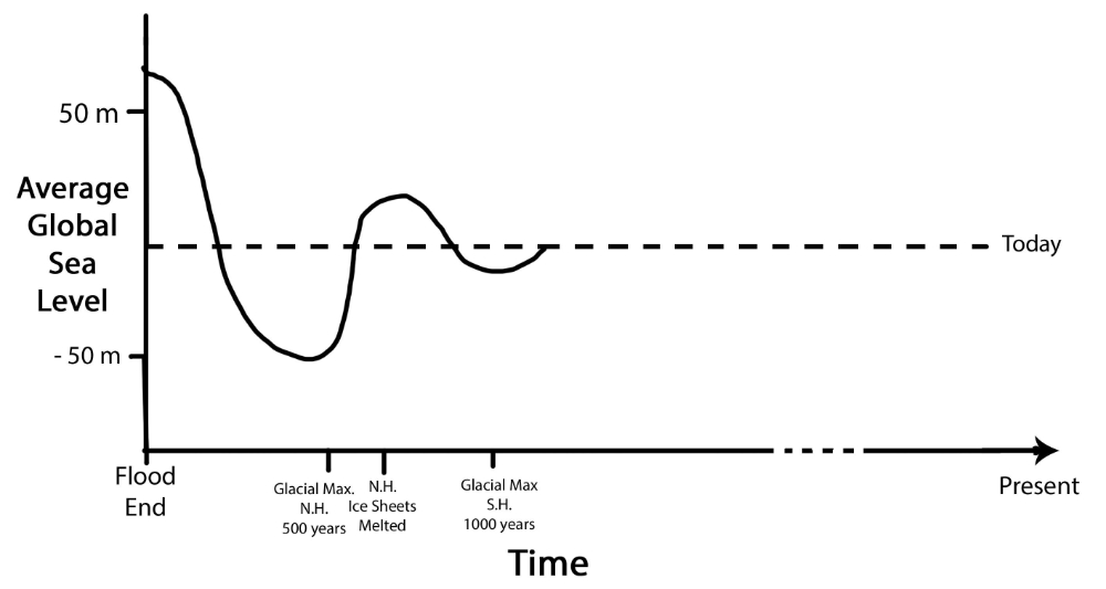
Because of the extreme difficulty of crossing the Bering Land Bridge late in the Ice Age, the old uniformitarian idea that the land bridge must have been tectonically raised early in the Ice Age seems more plausible. This is especially true since the sea level would have been about 68 m higher than it is today right after the Flood since there were no Antarctic and Greenland Ice Sheets (figure 11).
Several reasons favour this view. First, it is unlikely that God would have told Noah and the animals to spread over the earth knowing there was no way to accomplish this:
“Bring out with you every living thing that is with you of all flesh—birds and animals and every creeping thing that creeps on the earth—that they may swarm on the earth, and be fruitful and multiply on the earth” (Genesis 8:17, ESV).

It is more likely that He would have provided a way to reach Australia and the Americas soon after the Flood. Second, much warmer winters during the early and middle Ice Age period in Asia and North America (figure 9)57,58 would allow Ice Age animals, along with animals that cannot tolerate much cold, to cross the Bering Land Bridge into the Americas.
Third, an ice-free corridor from the north-west Yukon Territory to central Montana along the eastern slopes of the Rocky Mountains would have facilitated migration into the central United States and south into South America early in the Ice Age (figure 10).65 This corridor was likely caused by downslope, foehn winds blowing from the west, locally called chinook winds. These winds are often strong,66 warm, and dry, resulting in a thin winter snow cover today that easily melts in the spring. The air would have been fairly warm early in the Ice Age because of the warm North Pacific Ocean.
Fourth, it appears that the post-Flood animals arrived in the Americas early in the Ice Age. One powerful piece of evidence is that Columbian mammoths are found in central British Columbia, the centre of the Cordilleran Ice Sheet, below glacial till. This is evidence of their spread early in the Ice Age.67 At first this seems contradictory but has an easy explanation. At that time only the mountains of British Columbia were glaciated because the warm onshore flow of air would have kept the lowlands of British Columbia ice free. Some mammoths rounding the Bering Land Bridge and travelling down the ice-free corridor would have passed through the Peace River water gap in the Canadian Rockies and into the lowlands of central British Columbia, before they were covered by ice. Some mammoths died in central British Columbia, before ice filled up the lowlands, leaving their fossils behind under the glacial till.
Did the exotic large mammals in southern North America, Central America, and South America cross the Bering Land Bridge? We do not know for sure, since their fossils are not found along the path. But just because we do not find the fossils of say toxodons, glyptodons, and armadillos in Siberia, Alaska, and in the ice-free corridor, does not mean they did not make the trip. However, some of the large mammals that are found in the Americas have also been found in Siberia and Alaska. Besides indications that the Columbian mammoth made the journey, the ground sloth68,69 and the American mastodon70 are found in Alaska and the Yukon Territory as Ice Age fossils. Also found are camels, various horses, the yak, various bison, and the brown bear. The Beringian wolf from the far north made it down as far south as Wyoming.71 Moreover, fossils of the cave bear found only in Europe and Asia have probably now been found in southern Alberta.72
Summary
Although uniformitarian scientists are perplexed by biogeography, creation science can explain much of it. Giant log mats that were a result of the Genesis Flood would disperse many plants and animals around the world. The Dover Strait Land Bridge early in the Ice Age aided dispersal from continental Europe into the United Kingdom. Even hippos spreading as far as northern England that were eventually entombed together with cold-loving animals later in the Ice Age can be explained. The Bering Land Bridge was likely tectonically raised early in the Ice Age providing a way for animals to rapidly spread from the ‘mountains of Ararat’ into the Americas.
References and notes
- Statham, D., Plants and animals around the world: why are they found where they are? Creation 32(4):45–47, 2010; creation.com/plants-animals-biogeography. Return to text.
- Johnson, B., Biogeography: a creationist perspective, CRSQ 48(3):212–223, 2012. Return to text.
- Statham, D., Biogeography, J. Creation 24(1):82–87, 2010; creation.com/biogeography. Return to text.
- Snelling, A.A., Earth’s Catastrophic Past: Geology, creation & the Flood, Institute for Creation Research, Dallas, TX, pp. 163–182, 2009. Return to text.
- Oard, M.J., Dinosaur Challenges and Mysteries: How the Genesis Flood makes sense of dinosaur evidence—including tracks, nests, eggs, and scavenged bonebeds, Creation book Publishers, Powder Springs, GA, 2011. Return to text.
- Jenner, R.A., The scientific status of metazoan cladistics: why current research practice must change, Zoologica Scripta 33(4):293–310, 2004. Return to text.
- James, F.C. and Pourtless IV, J.A., Cladistics and the origin of birds: a review and two new analyses, Ornithological Monographs 66:1–78, 2009. Return to text.
- Heinicke, M.P., Duellman, W.E., and Hedges, S.B., Major Caribbean and Central American frog faunas originated by ancient ocean dispersal, PNAS 104(24):10092–10097, 2007; p. 10097. Return to text.
- Vences, M., Vieites, D.R., Glaw, F., Brinkmann, H., Kosuch, J., Veith, M., and Meyer, A., Multiple overseas dispersal in amphibians, Proceedings of the Royal Society of London B 270:2435–2442, 2003; p. 2437. Return to text.
- De Queiroz, A., The resurrection of oceanic dispersal in historical biogeography, Trends in Ecology and Evolution 20(2):68–73, 2005. Return to text.
- Winkworth, R.C., Wagstaff, S.J., Glenny, D., and Lockhart, P.J., Plant dispersal N.E.W.S. from New Zealand, Trends in Ecology & Evolution 17(11):514–520, 2002. Return to text.
- Statham, D., Phytogeography and zoogeography—rafting vs continental drift, J. Creation 29(1):80–87, 2015; creation.com/distribution-of-plants-and-animals. Return to text.
- Heaney, L.R., Is a new paradigm emerging for ocean island biogeography? J. Biogeography 34:753–757, 2007. Return to text.
- Cowie, R.H. and Holland, B.S., Dispersal is fundamental to biogeography and the evolution of biodiversity on oceanic islands, J. Biogeography 33:193–198, 2006; p. 196. Return to text.
- Cowie and Holland, ref. 14, pp. 193–198. Return to text.
- Censky, E.J., Hodge, K., and Dudley, J., Over-water dispersal of lizards due to hurricanes, Nature 395:556, 1998. Return to text.
- Calsbeek, R. and Smith, T.B., Ocean currents mediate evolution in island lizards, Nature 426:552–555, 2003. Return to text.
- Vences et al., ref. 9, pp. 2435–2442. Return to text.
- Houle, A., The origin of platyrrhines: an evaluation of the Antarctic scenario and the floating island model, American J. Physical Anthropology 109:541–559, 1999. Return to text.
- Ross, M.J., Evaluating potential post-Flood boundaries with biostratigraphy—the Pliocene/Pleistocene boundary, J. Creation 26(2):82–87, 2012; creation.com/biostratigraphy-post-flood-boundary. Return to text.
- Arment, C., To the Ark, and back again? Using the marsupial fossil record to investigate the post-Flood boundary, ARJ 13:1–22, 2020. Return to text.
- Arment, C., Fossil snakes and the Flood boundary in North America, J. Creation 29(1):58, 2015. Return to text.
- Araujo, B.B.A., Oliveira-Santos, L.G.R., Lima-Ribeiro, M.S., Diniz-Filho, J.A.F., and Fernandez, F.A.S., Bigger kill than chill: the uneven roles of humans and climate on late Quaternary megafaunal extinctions, Quaternary International 431:216–222, 2017. Return to text.
- Barnosky, A.D. and Lindsey, E.L., Timing of Quaternary megafaunal extinction in South America in relation to human arrival and climate change, Quaternary International 217:10–29, 2010. Return to text.
- Tyrberg, T., The late Pleistocene continental avian extinction—an evaluation of the fossil evidence, Oryctos 7:249–269, 2008. Return to text.
- Field, J., Fillios, M., and Wroe, S., Chronological overlap between humans and megafauna in Sahul (Pleistocene Australia–New Guinea): a review of the evidence, Earth-Science Reviews 89:97–115, 2008. Return to text.
- Barnosky, A.D., Koch, P.L., Feranec, R.S., Wing, S.L., and Shabel, A.B., Assessing the causes of late Pleistocene extinctions on the continents, Science 306(5693):70–75, 2004. Return to text.
- Faith, J.T., Late Pleistocene and Holocene mammal extinctions on continental Africa, Earth-Science Reviews 128:105–121, 2014. Return to text.
- Lyons, S.K., Smith, F.A., Wagner, P.J., White, E.P., and Brown, J.H., Was a ‘hyperdisease’ responsible for the late Pleistocene megafaunal extinction? Ecology Letters 7:859–868, 2004. Return to text.
- Nilsson, T., The Pleistocene: Geology and life in the Quaternary Ice Age, D. Reidel Publishing Co., Boston, MA, pp. 415, 428, 1983. Return to text.
- Oard, M.J., (ebook), The Genesis Flood and Floating Log Mats: Solving geological riddles, Creation Book Publishers, Powder Springs, GA, 2014. Return to text.
- Oard, M.J., Mid and high latitude flora deposited in the Genesis Flood part II: creationist hypotheses, CRSQ 32(3):140, 1995. Return to text.
- Wise, K.P. and Croxton, M., Rafting: a post-Flood biogeographic dispersal mechanism; in: Ivey Jr, R.L. (Ed.), Proceedings of the Fifth International Conference on Creationism, technical symposium sessions, Creation Science Fellowship, Pittsburgh, PA, pp. 465–477, 2003. Return to text.
- Snelling, ref. 4, p. 172. Return to text.
- Yoder, A.D. and Nowak, M.D., Has vicariance or dispersal been the predominant biogeographic force in Madagascar? Only time will tell, Annual Review of Ecology, Evolution, and Systematics 37:405–431, 2006; p. 423. Return to text.
- Wood, T.C. and Murray, M.J., Understanding the Pattern of Life: Origins and organization of the species, Broadman & Holman Publishers, Nashville, TN, p. 195, 2003. Return to text.
- Koch, P.L. and Barnofsky, A.D., Late Quaternary extinctions: state of the debate, Annual Review of Ecology, Evolution, and Systematics 37:215–250, 2006. Return to text.
- Cooke, S.B., Dávalos, L.M., Mychajliw, A.M., Turvey, S.T., and Upham, N.S., Anthropogenic extinction dominates Holocene declines of West Indian mammals, Annual Review of Ecology, Evolution, and Systematics 48:301–327, 2017. Return to text.
- Smith, A.J., A catastrophic origin for the palaeovalley system of the eastern English Channel, Marine Geology 64:65–75, 1985. Return to text.
- Gupta, S., Collier, J.S., Garcia-Moreno, D., Oggioni, F., Trentesaux, A., Vanneste, K., De Batist, M., Camelbeeck, T., Potter, G., Van Vliet-Lanoë, B., and Arthur, J.C.R., Two-stage opening for the Dover Strait and the origin of island Britain, Nature Communications 8:15101, 2017. Return to text.
- Oard, M.J., The Missoula Flood Controversy and the Genesis Flood, Creation Research Society Books, Chino Valley, AZ, 2004. Return to text.
- Oard, M.J., The Great Missoula Flood: Modern day evidence for the worldwide Flood, Awesome Science Media, Richfield, WA, 2014. Return to text.
- Hjelstuen, R.O., Sejrup, H.P., Valvik, E., and Becker, L.W.M., Evidence of an ice dammed lake outburst in the North Sea during the last deglaciation, Marine Geology 402:118–130, 2018. Return to text.
- Nilsson, T., The Pleistocene—Geology and life in the Quaternary Ice Age, D. Reidel Publishing Co., Boston, MA, pp. 223–233, 1983. Return to text.
- Sutcliffe, A.J., On the Tracks of Ice Age Mammals, Harvard University Press, Cambridge, MA, p. 24, 1985. Return to text.
- Stuart, A.J., Pleistocene Vertebrates in the British Isles, Longman, London, UK, p. 52, 1982. Return to text.
- Sutcliffe, ref. 45, p. 120. Return to text.
- Stuart, A.J., Late Quaternary megafaunal extinctions on the continents: a short review, Geological J. 50:338–363, 2015. Return to text.
- Sutcliffe, ref. 45, p. 24. Return to text.
- Van Kolfschoten, T., The Eemian mammal fauna of central Europe, Netherlands J. Geosciences 79(2–3):269–281, 2000; p. 270. Return to text.
- Stuart, A.J., Mammalian extinctions in the late Pleistocene of northern Eurasia and North America, Ecological Reviews 66:453–562, 1991. Return to text.
- Grayson, D.K., Historical background and the beasts themselves; in: Martin, P.S. and Klein, R.G. (Eds.), Quaternary Extinctions: A prehistoric revolution, The University of Arizona Press, Tucson, AZ, p. 16, 1984. Return to text.
- Nilsson, T., The Pleistocene: Geology and life in the Quaternary Ice Age, D. Reidel Publishing Co., Boston, MA, p. 227, 1983. Return to text.
- Reworking is a common dodge used by uniformitarian, evolutionary scientists to dismiss anomalous fossils. Return to text.
- Graham, R.W. and Lundelius, E.L., Coevolutionary disequilibrium and Pleistocene extinctions, Unknown J. 223–249, 1984. Return to text.
- Grayson, ref. 52, p. 18. Return to text.
- Oard, M.J., An Ice Age Caused by the Genesis Flood, Institute for Creation Research, Dallas, TX, 1990. Return to text.
- Oard, M.J., Frozen in Time: Woolly mammoths, the Ice Age, and the biblical key to their secrets, Master Books, Green Forest, AR, 2004. Return to text.
- Hoffecker, J.R., Elias, S.A., O’Rourke, D.H, Scott, G.R., and Bigelow, N.H., Beringia and the global dispersal of modern humans, Evolutionary Anthropology 25:64–78, 2016. Return to text.
- Yokoyama, Y., De Deckker, P., Lambeck, K., Johnston, P., and Fifield, L.K., Sea-level at the last glacial maximum: evidence from northwestern Australia to constrain ice volumes for oxygen isotope stage 2, Palaeogeography, Palaeoclimatology, Palaeoecology 165:281–297, 2001. Return to text.
- Woodburne, M.O. (Ed.), Cenozoic Mammals of North America: Geochronology and biostratigraphy, University of California Press, Berkley, CA, 1987. Return to text.
- It also is possible, though, that the land bridge was not tectonically raised and that log mats helped the animals cross the Bering Strait. This does not seem likely since some of the animals were very large, such as the mammoths, mastodons, and ground sloths, and may not have been able to walk on a log mat. Return to text.
- Oard, M.J., Evidence strongly suggests the Laurentide Ice Sheet was thin, J. Creation 30(1):97–104, 2016. Return to text.
- Oard, M.J., Non-glacial landforms indicate thin Scandinavian and British-Irish Ice Sheets, J. Creation 31(2):119–127, 2017. Return to text.
- An inland corridor was likely needed because, despite the coast being warmed by the warm ocean water early in the Ice Age, the sea level would have been higher, and there were strong storms in the Gulf of Alaska, and mountains blocking the path. Return to text.
- Oard, M.J., A method for prediction chinook winds east of the Montana Rockies, Weather and Forecasting 8(2):166–180, 1993. Return to text.
- Harington, C.R., Tipper, H.W., and Mott, R.J., Mammoth from Babine Lake, British Columbia, Canadian J. Earth Sciences 11(2):285–303, 1974. Return to text.
- Stock, C. and Richards, H.G., A megalonyx tooth from the Northwest Territories, Canada, Science 110:709–710, 1949. Return to text.
- McDonald, H.G., Harington, C.R., and De Iuliis, G., The ground sloth, Megalonyx 53(3):213–220, 2000. Return to text.
- Zazula, G.D. et al., American mastodon extirpation in the Arctic and Subarctic predates human colonization and terminal Pleistocene climate change, PNAS 111(52):18460–18465, 2014. Return to text.
- Meachen, J.A., Brannick, A.L., and Fry, T.J., Extinct Beringian wolf morphotype found in the continental U.S. has implications for wolf migration and evolution, Ecology and Evolution 6(10):3403–3438, 2016. Return to text.
- Reynolds, A.R., Seymour, K.L., and Evans, D.C., Late Pleistocene records of felids from the Medicine Hat, Alberta, including the first Canadian record of the sabre-toothed cat, Smilodon fatalis, Canadian J. Earth Sciences 56(10):1052–1060, 2019. Return to text.


Readers’ comments
Comments are automatically closed 14 days after publication.