

Journal of Creation 27(1):107–113, April 2013
Browse our latest digital issue Subscribe
Why was the UK once totally under water?
The teaching of geology is dominated by an irrational desire to avoid any reference to the biblical Flood when the whole world was submerged under water recently. It achieves this by burrowing into small, detached details and carefully ignoring the bigger picture. This paper examines the bigger picture in the UK, drawing together diverse aspects of geology, geography and the hydraulics of river flow to show that the UK experienced a complete flood recently. But many other factors are also uncovered that point to the whole world having experienced that same flood.
Geology, as currently taught in schools, colleges and universities, knows nothing of the Noachian Flood when, according to the Bible, the whole world was submerged under water recently (thousands, not millions, of years ago). Textbooks and journals on geology universally reiterate uniformitarianism (the assumption that the present is the key to the past) as being a necessary and sufficient way of studying geology. The biblical Flood is sidelined by this bondage to uniformitarianism.
Neither is there any reference in this ‘bondage’ geology to the large number of non-biblical flood legends from many parts of the world which add support to the principle of a global flood. These should have prompted a serious study before geology became entrapped by uniformitarianism, which is hardly liberated by admission of the occasional catastrophe.1,2
Our focus in this paper is to show that when we examine geology holistically, rather than burrowing ourselves in small detached details, confirmation of the recent Flood emerges.
The UK, because of its relatively small size compared with the world’s land mass and the early development of geology here, has been explored to a higher level of detail than many other countries. This paper presents evidence from within the uniformitarian paradigm that the UK experienced a complete flood recently. In the process we show that there are also other pointers, quite independent of flood legends, to the whole world having experienced a global flood. Other researchers are then encouraged to complete this story geologically.
The biblical account
Genesis 7–8 describes at least six aspects of Noah’s Flood which we ought to be able to confirm if the event was part of real history rather than a myth or a local flood. These points were ignored as Lyell developed uniformitarianism.3 Sadly, these are often ignored even by respected evangelicals.4 The points have been discussed regularly since the seminal work by Whitcomb and Morris5 and updated in many recent substantial works such as Snelling.6 They are:
- New sources of water from the fountains of the great deep and the windows of heaven (Genesis 7:11).
- Unusual rain for 40 days (7:12).
- All high mountains covered with water to a depth of at least around 6 metres (7:19, 20).
- Rapid submergence of landscape—less than five months (7:18–24).
- Death to all air-breathing, land-dwelling creatures (7:22).
- Rapid retreat of the Flood (8:1–14).
Furthermore, the implication of items 3, 4, and 5 is that the whole Earth was simultaneously covered with water. Isaiah 54:9 and 2 Peter 3:6 provide additional confirmation. This is the main issue we will address with specific reference to the UK.
A worldview
Hancock and Kauffman7 estimate that at the end of the ‘Cretaceous’ period the amount of dry land worldwide was around one half of what it is now. Although young-earth creationists are unlikely to readily accept the uniformitarian meaning of ‘Cretaceous’ or the millions of years associated with it, it provides a starting point for our study.
Mount Everest, the highest in the world at 8,848 m above sea level, is composed of limestone and once lay beneath what such geologists call the Tethys Ocean in the ‘Late Cretaceous’. Limestone is a rock that is formed under water and contains (marine) crinoid fossils.8
Everest supposedly started to come up out of the water 50 Ma (million years ago) as India supposedly collided with the European Plate causing the Himalayas to form.
The uplift was completed at 5.5 Ma.9 We are neither going to discuss how the individual dates were obtained nor take them at face value. We will discuss the concept of ‘deep time’ later, but we also have to note that radiometric dating is totally unreliable because decay rates have not been constant,10 though this is not admitted in geological articles.
Later we will show that aspects of tectonics, erosion, and sedimentation provide overwhelming support for Vardiman et al.’s10 conclusion that radiometric dates of rocks need to be shortened by removing four to six trailing zeros from the age. There is no such thing as ‘deep time’, though we will live with the concept temporarily as we survey the uniformitarian literature.
There is a further point that has to be challenged. Ascribing relative ages to rocks in different areas through a casual use of the stratigraphic geological column is outmoded.11,12 Each case needs examining individually. For the moment we will use the terminology of the geological column to provide the relative dates of the rocks since our first aim is to show uniformitarian geologists that, even within their own paradigm, there is substantial evidence for the global flood. Later we will challenge this method of relative dating.
UK mountains and peaks
Bringing our focus back to the UK, because of the wealth of geological information, we start with England. England’s highest peak is Sca Fell, in the Lake District, at just short of 1,000 metres. The area is one of structural complexity13 with rocks of the Borrowdale volcanic group (BVG) deposited supposedly in the ‘Ordovician’ period (~450 Ma) being the dominant surface rocks. However, these are underlain by the Tarn Moor Mudstones deposited in water. So the area was once under water at least 450 Ma.
Now while the current consensus favours a subaerial (i.e. exposed to the air) setting for the BVG, it is possible that the subaerial nature of the BVG has been overstated.14 Thus the area may have remained under water even much later. Note that we are putting names from the geological column, such as ‘Ordovician’ and ‘Cretaceous’ in quotes because of our reservations about their overwhelming uniformitarian connotation.
There are four reasons Garner14 gives for the possible watery origin of the BVG rocks:
- The welding of ignimbrites has been cited in support of the subaerial interpretation, but this has been strongly challenged by field and theoretical studies demonstrating that welding can take place underwater and may even be more likely underwater. Notably, BVG ignimbrites are often underlain or overlain by subaqueously deposited pyroclastics.
- Attention has been drawn to lava flows with features suggesting weathering in a subaerial environment. However, many of these ‘extrusive lava flows’ have now been reinterpreted as ‘intrusive sills’, which were never exposed to the atmosphere. Their weathered appearance is due to interaction between the hot magmas and the wet sediments into which they were intruded.
- Many of the bedded tuffs in the BVG display evidence of having been deposited underwater or reworked by water. Observed structures include ripples, channels, slumps, cross bedding, graded bedding, flute marks and load casts. In some locations, such as Pavey Ark, the volcanic breccias are interpreted as hyaloclastites (glassy) which formed when lava was rapidly chilled and fragmented by contact with water.
- Fossil-bearing marine mudstones of the Holehouse Gill Formation occur in the upper part of the BVG, although this is regarded as a brief, localised incursion into an otherwise subaerial succession.
Turning our attention to other high spots in the UK, the highest mountain in Wales is Snowdon (1,085 m). At its simplest, it is now a series of irregular-shaped plugs of igneous rock, but these plugs pierced a series of layers of mudstone, which had been laid down under water supposedly around 500 Ma (‘Cambrian’). The mudstone has been tilted almost to the vertical and has been compressed and heated into slate.15,16
Scotland’s highest mountain, and the highest in the UK, is Ben Nevis at 1,343 m. The reason we can be sure the area was once under water is similar to the story for Sca Fell and Snowdon. Much of the area is metamorphic rock,17 but Ben Nevis emerged from depth as a granite intrusion, displacing the water-deposited sediments, which then transformed the surrounding country rock into metamorphic rock by the heat from the granite.
In Northern Ireland, the highest mountain is in the Mourne range (852 m). Though the mountain range is granite, it is underlain by slate and shale. Thus the area was under water supposedly 440 Ma.
Was every part under water at the same time?
In order to validate the biblical account of the Flood from geological evidence, it is not sufficient, though it was helpful as a precursor, to show that all our mountains were once under water. We need to ask if the whole of the UK was simultaneously under water recently.
Our foray into the uniformitarian literature to answer these questions, ignored by those who practise uniformitarianism, starts with our figure 1, taken from Rayner,18 and based on primary sources such as Hancock and Rawson.19 In what is described as the ‘Late Cretaceous’ period and dated around 65 Ma, her composite map shows all of England, much of Wales, and major parts of Scotland under water. It also shows the whole of the Ireland landmass under water, as well as major parts of continental Europe. Furthermore, this map is regarded as ‘conservative’ by Rawson20 and Gannon,15 who point out that a ‘radical’ view of the exposed land mass of Britain around 65 Ma is smaller than Rayner’s map shows, and may even have been nonexistent.
Others who have studied the ‘Cretaceous’ period have maps which show a small island of land in the Lake District (LD), and an extension of area ‘W’ to the south to include the Brecon Beacons (BB); for example, Gale.21 Rawson,20 in a solo-authored article, apparently contradicting what is described above, shows the area ‘W’ to be in the south of Wales rather than the north (his figure 12.2B). The latter is possibly a draughtsman’s error because of the relative heights of the respective areas. Whatever the individual causes for the differences, part of the explanation is the problem of identifying which igneous deposits were subaerial and which were subaqueous, as mentioned above.
Even taken at face value, this map is a step in the direction of showing a positive answer to our first question. It is wrong for all those who cling to uniformitarianism, supported by a bit of catastrophism, to dismiss the global flood without performing basic checking. The loss of 80–90 % of the land surface of the UK all at once is catastrophic in our biblical context. But our story of restoring credibility in the exact biblical details of the global flood has further mettle in it yet because we have more to say about Wales, even if we cannot at this stage explain all the outliers in figure 1.
The area in Wales (marked W) is Snowdonia. From our discussion above we know that it was definitely under water ~500 Ma. As noted, some geologists will also accept that it was under water ~65 Ma22 though it may not have stayed under water during the intervening time.
Another reason for the difference in opinion arises from the uncertainty in the depth of the ocean when the chalk was being deposited. Chalk is present in England southeast of a line from Hunstanton to Abbotsbury. There is also a smaller area near Flamborough and patches west of Abbotsbury. Because of the erosion that took place from the NW (see below), chalk is judged to have been deposited much further NW than where it is presently found. A conservative estimate19 is that it occupied the whole area SE of a line from Flamborough to Exeter. Traces of chalk are also found in the Hebrides, Northern Ireland and SW Ireland in collapse structures.21 This implies a significant cover of chalk at one stage in Earth’s history, much further than Hancock and Rawson19 estimated.
The depth of the ocean when chalk was being deposited is considered to have been 100–600 m (Rayner).18 Since the chalk is pure (no land-based clastics or organic matter in it), land must have been even further away than NW of this Flamborough-Exeter line. This is one of the reasons behind the statement that much, if not all, of the UK was under water at that one time. Only where the landscape islands (outliers) are shown (W, S1, S2, and S3) is there residual doubt that that they were not under water exactly at this point in time.
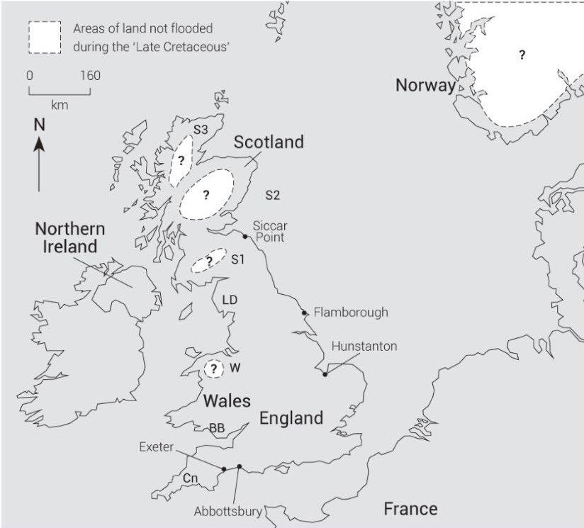
A further question is the relative height of the Snowdonian area and the other outliers in figure 1, during the ‘Cretaceous’. The height was what it is today, plus what was eroded in the ‘post-Cretaceous’ period less any rise in the basement rocks. Estimates of as much as 1.5 to 2.0 km for the additional height exist. Obviously, these put Snowdon above water, but these heights are ‘guesstimates’. If there was land in those positions, then there would be a high probability of land-derived clastics in the chalk. They don’t exist. The estimates of heights are based on the recognition that the dykes and the host rocks in these areas were once topped with much more ‘over-burden’ than they are now.
However, since the bulk of this ‘over-burden’ has since disappeared, we know that the top of the ‘over-burden’ was once under water much later than that first igneous intrusion, and that that water must have had extensive erosive power to remove that additional ‘over-burden’. This ‘Late Cretaceous’ period seems to fit closely.
The crucial evidence which could settle the issue is often buried under later glacial deposits. The issue of radiometric dating is of no help. While to a uniformitarian geologist the ‘Devonian’ and ‘Cretaceous’ periods are separated by ~200 million years, the RATE study10 shows that the details are severely suspect. Later we will examine other aspects of river flow in the region and how that this casts light on the subject in favour of our interpretation.
The three areas in Scotland which might have been under water ~65 Ma (S1 is the Southern Uplands, S2 is the Grampian area and S3 is the Northern Uplands) could be explained in the same way. The area in Norway needs further research but is likely to prove more difficult to unravel because of the greater degree of glacial history frustrating efforts to uncover material which may be ‘Late Cretaceous’. Additional information is currently available for the other parts of continental Europe 23 not shown on figure 1, but further research is needed. The area Cn on the figure is Cornubia (named after Cornwall), and will be referenced later.
Deep time
There will be objections at this stage to our hypothesis that all parts of the UK were simultaneously under water within the past few thousand years, because the submergence of the land that we have demonstrated has been assigned an age of ~65 Ma. This is not the 4,500 years for the date of the Flood based on biblical genealogies. 24
Hutton promoted the concept of ‘deep time’ at the end of the 18th century.25 His observation of erosion in present-day rivers showed very slow rates. Therefore the courses the rivers follow must be old, so the rocks over which these rivers flowed must be old.
His line of reasoning based on erosion fails when we consider the Flood. When rocks were deposited they would have been unconsolidated and therefore amenable to rapid erosion. Hardening (consolidation) may have taken hours, days or even months depending on location, burial history, and the arrival of other mineral-rich waters.26 The rates of erosion would therefore have been very variable rather than always slow.
The folding and erosion at Siccar Point in Scotland is a specific example Hutton used to justify ‘deep time’. The area is quite small so it is difficult to provide a detailed explanation of what happened there. Considering the iconic nature that uniformitarians hold of it, there is a paucity of literature. Probably the best description of it is that of Rowan (website).27 Challenges to the assumption that a long period was needed to fold and erode the Silurian rocks have been made by Tyler on the BCS website,28 and Walker.29
Justifying ‘deep time’ by reference to radiometric dating is not acceptable. Radiometric dates overestimate rock ages by several orders of magnitude.10 Those estimates of land in ‘Late Cretaceous’ times (figure 1) are therefore what happened not 65 Ma, but just a few thousand years ago.
It may be that radiometric dates can be used to assess relative dates.30 However, many creationists go further and accept Humphreys’ dictum (in Vardiman et al. 200031) that there is a guaranteed one-to-one correspondence between radioisotopic age and stratigraphic age (p. 342, figure 3). The data are far from complete, but that guarantee is suspect for two reasons. The standard deviation of the data using radioisotopic age to obtain stratigraphic age is about 180 Ma (i.e. 3–4 geological periods).
To show what this means, consider a rock sample (T), radioisotopically assessed, which, from that dictum, gives a stratigraphic age of ‘Triassic’, and another sample (P) from a distant location (where the strata provide no supplementary clues to their relative ages) that gives an older ‘Permian’ age. Yet there is a 30% probability that P is younger than T. Such strata are therefore inferred the ‘wrong way round’ 30% of the time.

We can try and reduce the standard deviation by Bayesian regression on the data in the hope of getting better relative dating estimates. What happens then is that the standard deviation is reduced to 120 Ma. But the trend line no longer goes through the origin. The line (in Ma) is: stratigraphic age equals 0.4 times radiometric age plus 180. That is not helpful to anyone since it pushes many rock samples immediately into the ‘Triassic’. The whole issue needs re-examining outside a framework of belief in the absolute reliability of the geological column. For the moment, with the support from overwhelming stratigraphic evidence,12,32 we assume that the geological column is an outmoded paradigm that has the potential to cause confusion rather than give light.
The retreat of the Flood
The uniformitarian understanding of what happened after this total (or almost total) immersion of the UK ~65 Ma was that the area started to uplift in the Irish Sea because of thermal doming.33,34 This is seen as one cause of a general stratigraphical tilt towards the southeast in England and Wales. Cope32 places the apex of the dome between Anglesey (A on figure 2) and the Isle of Man (I). So the overlying water would have had to run off radially from this position because a cone-like structure would be emerging. Thus over England and Wales the flow would be towards the south and east.

Thompson35 objects to the doming because the thermal dome would have eventually subsided, to which Cope36 replies that that is why the Irish Sea is now sea, rather than land. Both authors agree that some kind of ‘igneous underplating’ (bolstering up) would also have been necessary to explain the runoff processes. The precise cause of the tilting on Wales and England is not important to our thesis, though there is a further supporting point for the uplift centred on what is now the Irish Sea. There is little or no sediment that would be left there in the Irish Sea21 if the major doming had not taken place there.
Uniformitarian geologists have traced the subsequent events. Initially, short rivers developed in the northwest, creating a large delta lagoonal complex covering much of what was to become England. Figure 2 shows this situation in ‘Late Palaeocene’ ~55 Ma (Gibbard and Lewins33). The ancient rivers have been named either after modern day rivers that follow similar courses (Trent and Thames) or geographical names (Solent and Hampshire). These earlier tracks have been ascertained by discoveries of gravel deposits consistent with erosion at upstream positions.37 The present-day river courses are due to recent earth movements, and the ice age adjusting the drainage patterns, see later.
The grey colour shows land within the boundary of the present outline of the UK. Obviously there might have been land in the Irish Sea, and the North Sea where the question marks have been placed. A further point is that the delta lagoonal complex would have been receiving water and sediment from separate uplift of France and other parts of continental Europe, but not Ireland, which was tilted the opposite way. Those details are still to be explored.
Subsequently the shore of the delta tracked further SE across England and the rivers lengthened. By ‘Late Eocene’ times (Bartonian ~ 40 Ma) the delta had disappeared, leaving the London Basin and the Hampshire-Dieppe Basin (figure 3). The rivers at this point in time are described as ‘Eocene Amazons’ or ‘Mississippis’ (Gibbard and Lewins33). Figure 3 gives a possible reconstruction of their courses between ‘Eocene’ and ‘Quaternary’ times (~2 Ma) based on a wide range of sources. Total agreement is not available on all the courses, probably due to geologists using uniformitarianism when it is not applicable, but there is general agreement, especially on the Solent and Thames.
Both the real Amazon and Mississippi are mighty rivers. The flows of water are huge compared with the UK’s Thames and Trent. So are the widths of these rivers—many kilometres, especially near the estuaries. Furthermore, unlike the Amazon and Mississippi, there were many of these rivers almost on top of each other, not thousands of kilometres apart.
The western head of the Thames was subsequently captured by the south-flowing Severn. Of other interest is the Solent, which has since disappeared. The interpretation is that the headwaters were in North and South Devon (D1).
It flowed across Dorset (D2) and on into Hampshire (H). It was less influenced by the doming north of Wales because land was also emerging, or had emerged in Cornwall and part of Devon (Cornubia—Cn on figure 1). East and away from Cornubia, the river failed to develop in any southerly direction because of folding in the chalk (see map) that restrained the flow against the NW-SE tilt. Development of this river is described in detail by Velegrakis, Dix, and Collins,38 along with the ultimate breaching of the chalk fold that created Poole and Bournemouth Bays (just above the ‘d’ in the word ‘Folding’ on the map). This breaching was quite late—‘Quaternary’ times ~2 Ma. Two short rivers now cross Dorset where the Solent once flowed (Piddle and Frome) but their headwaters do not stretch back to Devon because of more recent uplift of land in Devon and Dorset.
The ‘unnamed’ river in Wales would set the scene as a precursor for several short rivers in that area (Towy, Loughor, Tawe, and possibly the upper reaches of the Usk and Wye). Jones22 discusses how these recently developed rivers evolved from that earlier drainage system.
The key question in our minds, once we free ourselves from the bondage of uniformitarianism, is what sustained these UK rivers of Amazonian size in terms of width and ability to create that amazingly large lagoonal complex basin. The rivers were only fractions of the length of the Amazon and Mississippi, which need large rain-catchment areas to sustain them. So either it rained 100 to 1,000 times as much as it does today in the UK (an average of about 1 m per year) or the life of these ‘Eocene Amazons’ was short-lived (just days). This would have been because the land was uplifting in the NW (with a corresponding tilting down towards the SE, shedding huge volumes of floodwater)—not at the rate of around 1 mm/20 years that uniformitarian Cope32 offers, but centimetres to metres a day.
Both optional answers are ignored by this geological bondage. In fact, the question is not even considered. The result of the rainfall figures suggested would leave all the ground continuously flooded with sheets of water, except for the highest ground. The most obvious answer to what sustained these rivers is therefore the rapid uplift of the ocean floor so that water flow was generated by retreat of the ocean. Note that the rates of uplift mentioned are in ballpark agreement with those described in Genesis about the rate of the retreat of the Flood.39
Large portions of the UK would then have been out of the water within months, though of course, the biblical data specifically refers to Ararat, not the UK. By making this choice of answer we have removed 10–30 Ma from Earth’s recent history, condensing the Palaeocene’, and parts of the ‘Eocene’ into a matter of months. The sustaining of the Proto Solent until the Quaternary (Velegrakis et al.37) with its immense erosive powers in the present Solent/Isle of Wight area suggests that the ‘Oligocene’, the ‘Miocene’ and possibly the ‘Pliocene’ lasted only a few months rather than ~30 Ma commonly assigned to the total duration of these epochs. The estuary of the Thames moved south about 20 km in ‘Quaternary’ times (Green and McGregor40).
Further discussion on the UK outliers of ‘cretaceous’ age
Figure 1 shows UK outliers of rock older than ‘Cretaceous’ age which were possibly not submerged during that period. That would mean that the Flood was not as complete as the Bible indicates even within this part of Europe or else this major amount of submergence had nothing to do with the biblical Flood. There are three points which, collectively, are robust enough to resolve the problem that the Bible states that all land was once submerged, even if one or two of them on their own are judged insufficient by those who are desperate to deny the global flood.
First, remember that radical uniformitarian geologists do not consider that any of these outliers existed in the ‘Late Cretaceous’ period. For the purpose of this discussion we are accepting that the maps provided by these geologists have captured the fact that at a unique point in time (what they call ‘Cretaceous’) no land existed across what is now the whole of the UK. So on the basis of their own data, the Flood was total. Additionally we have shown, independently of the unacceptable radiometric dating, and using their own data based on the behaviour of those ‘Amazonian’ rivers, that this event was much more recent than 65 Ma.
Second, suppose that figure 1 is an accurate reflection that these outliers were real features during the ‘Late Cretaceous’ as a unique period of time in the UK as Rayner18 and
others contend. We have already established that this was much more recent than 65 Ma. Then, as land lifted, at the high rates we have shown to be applicable in the Anglesey/Isle of Man area, huge waves of water could have formed, possibly tsunamic in character. These would have had the potential to swamp the surfaces of the outliers. So there was a definite potential for every part of the UK to be submerged simultaneously at least for a few days.
The third point is based on the recognition that, just because a uniformitarian geologist dates a rock using data from the geological column, it does not guarantee that that rock was deposited at the same time as other rocks labelled with the same geological name at other places on Earth. Take the point in time that the bulk of the UK was under water, figure 1. This has been assigned a ‘Late Cretaceous’ age. But it is wrong to say categorically that the outliers, which conservative uniformitarians judge to be pre–‘Cretaceous’ rocks, were pre–‘Cretaceous’ rocks, when there is a significant probability of them being the same or a younger age. (Probabilities have been discussed above.)
Neither the fossil content nor radiometric dating, where available, can provide convincing equivalence of the time. As an independent example of the confusion over relative dating, consider the folding of the abovementioned chalk ridge, and the obvious inference that a single folding event took place simultaneously in the ‘Cretaceous’ and ‘Tertiary’ rocks.11 We have here evidence of the blurring of the periods geological names refer to, and independent verification of the ability to take 20–30 Ma off our recent history.
Whatever argument one endeavours to make for explaining away the ‘conservative’ outliers in figure 1, there is minimal evidence that the whole of the UK was not fully under water in the recent past. The onus is on the uniformitarians to prove otherwise.
Other parts of the world
Figure 1 is limited to the region around the UK. Now a global flood means a global flood. There are two points that indicate that the rest of the world was covered with water at the same time. We have a series of worldwide flood legends.41 And geologically we have the estimate7 of a major loss of land worldwide in the ‘Cretaceous’.
If better exploration and the removal of some dubious assumptions were carried out (such as relinquishing the geological column) all that land would probably disappear at a unique point in time, though we would not be able to call it ‘Cretaceous’.
Summary and new challenges
We have challenged the hypothesis that the earth was not subjected to a global flood within the past few thousand years, using mainly uniformitarian sources of information.
We first showed that the UK’s mountains were once under water (as described in Genesis 7:19). Then we identified geological maps which show that at a time called ‘Late Cretaceous’, 80–90% of our present UK land did not exist.
Although these ‘conservative’ maps suggest that only 80–90% of the UK was under water at exactly the same time, we have advanced three reasons to suggest that 100% of the land was under water.
We have also produced evidence, based on river flow, to show that this submergence was recent. The challenge now is to widen the study of evidence for a global flood to neighbouring countries. The potential already exists based partly on uniformitarian maps and the realization that the geological column is not a robust concept. We also need to encourage other evangelicals to engage in studying the effects of the Flood rather than hiding behind uniformitarianism because they consider that “evidence (of the global flood) would not have been overlooked, had it existed” (White4).
References and notes
- Ager, D.V., The New Catastrophism, Cambridge University Press, Cambridge, 1993. Return to text.
- Selley, R., Applied Sedimentology, Academic Press, London, 2000. Return to text.
- Lyell, C., Principles of Geology, (vol. 1), John Murray, London, 1830. Return to text.
- White, R.S., Book Reviews, Science and Christian Belief 12(1):75, 2000. Return to text.
- Whitcomb, J.C. and Morris, H.M., The Genesis Flood, Presbyterian and Reformed Publishing Co, 1961. Return to text.
- Snelling, A.A., Earth’s Catastrophic Past, ICR, Dallas, TX, 2009. Return to text.
- Hancock, J.M. and Kauffman, E.G., The great transgression of the Late Cretaceous, J. Geol. Soc. London 136:175–186, 1979. Return to text.
- Oard, M., Flood by Design, Master Books, Green Forest, AR, 2008. Return to text.
- Stow, D., Vanished Ocean—How Tethys Reshaped the World, Oxford University Press, Oxford, 2010. Return to text.
- Vardiman, L., Snelling. A.A. and Chaffin, E.F., Radioisotopes and the Age of the Earth, vol. 2, ICR and CRS, El Cajon, CA and Chino Valley, AZ, 2005. Return to text.
- Matthews, J.D., Chalk and ‘Upper Cretaceous’ Deposits Are Part of The Noachian Flood, Answers Res. J. 2:29–51, 2009. Return to text.
- Matthews, J.D., The stratigraphic geological column—a dead end, J. Creation 25(1):98–103, 2011. Return to text.
- Bassett, M.G., Wright, AD and Duff, P.M.D., Ordovician; in: Duff, P.M.D. and Smith, A.J. (Eds.), Geology of England and Wales, The Geological Society, London, pp. 63–146, 1992. Return to text.
- Garner, P., Catastrophic volcanism in the Borrowdale Volcanic Group (Ordovician) of the English Lake District, Proceedings of the Fifth European Creationist Congress, Biblical Creation Society and Creation Science Movement, England, pp. 23–28, 1992. Return to text.
- Gannon, P., Rock Trails—Snowdonia, Pesda Press, Ltd, Gwynedd, 2008. Return to text.
- Roberts, B., The Geology of Snowdonia and Llyn, Adam Hilger Ltd, Bristol, 1979. Return to text.
- Trewin, N.H., Geology of Scotland, Geological Society, London, 2002. Return to text.
- Rayner, D.H., The Stratigraphy of the British Isles, Cambridge University Press, Cambridge, 1981. Return to text.
- Hancock, J.M. and Rawson, P.F., Cretaceous, Geol. Soc. London Mem. 13:131–139, 1992. Return to text.
- Rawson, P.F., The Cretaceous; in: Duff, P.M.D. and Smith, A.J. (Eds.), Geology of England and Wales, The Geological Society, London, pp. 335–388, 1992. Return to text.
- Gale, A.S., Late Cretaceous to Early Tertiary pelagic deposits; in: Woodcock, N. and Strachan, R. (Eds.), Geological History of Britain and Ireland, Blackwell Science, Oxford, pp. 356–373, 2000. Return to text.
- Jones, O.T., The drainage system of Wales and the adjacent regions, J. Geol. Soc. London 107:201–225, 1951. Return to text.
- Tyson, B.V. and Funnel, B., M., Global and European Cretaceous Shorelines; in: Ginsberg R. and Beaudoin, B. (Eds.), Cretaceous Resources, Events and Rhythms, Kluwer Academic Press, Dordrecht, pp. 237–272, 1990. Return to text.
- Hill, C., The English Bible and the Seventeenth-Century Revolution, Allen Lane, London, 1993. Return to text.
- Hutton, J., Theory of the Earth with proofs and illustrations, Edinburgh Geological Society, 1785. Return to text.
- Matthews, J.D., The origin of oil—an answer from creationism, Answers Res. J. 1:123–146, 2008. Return to text.
- Rowan, C., The making of an angular unconformity: Hutton’s unconformity at Siccar Point, all-geo.org, 27 January 2011. Return to text.
- Tyler, D, Revisiting Hutton’s unconformities, biblicalcreation.org.uk, 24 April 2003. Return to text.
- Walker, T.B., Unmasking a long-age icon, Creation 27(1):5055, 2004; creation.com/hutton-siccar-point. Return to text.
- Baumgardner, J., Do radioisotope methods yield trustworthy relative ages for the earth’s rocks? J. Creation 26(3):68–75, 2012. Return to text.
- Vardiman, L., Snelling. A.A. and Chaffin, E.F. (Eds.), Radioisotopes and the Age of the Earth, vol. 1, ICR and CRS, El Cajon, CA, and Chino Valley, AZ, 2000. Return to text.
- Oard, M.J., Is the geological column a global sequence? J. Creation 24(1):56–64, 2010; creation.com/geo-sequence. Return to text.
- Cope, J., A latest Cretaceous hotspot and the southeasterly tilt of Britain, J. Geol. Soc. London 151(6):905–908, 1994. Return to text.
- Gibbard, P.L. and Lewin, J., The history of major rivers of southern Britain during the Tertiary, J. Geol. Soc. London 160(6):829–845, 2003. Return to text.
- Thompson, K., Discussion on a latest Cretaceous hotspot and the southeasterly tilt of Britain, J. Geol. Soc. London 152(4):729–731, 1995. Return to text.
- Cope, J., Discussion on a latest Cretaceous hotspot and the southeasterly tilt of Britain, J. Geol. Soc. London 152(4):729–731, 1995. Return to text.
- Watts, A.B., McKerrow, W.S. and Richards, K., Localised Quaternary uplift of southcentral England, J. Geol. Soc. London 162(1):13–24, 2005. Return to text.
- Velegrakis, A.F., Dix, J.K. and Collins, M.B., Late Quaternary evolution of the upper reaches of the Solent River, J. Geol. Soc. London 156(1):73–87, 1999. Return to text.
- Matthews, J.D., Jurassic Ark, A journey through time with Noah, Avenue Books, UK, 2009. Return to text.
- Green C.P. and McGregor, D.F.M., Quaternary evolution of the River Thames; in: Jones, D.K.C. (Ed.), The Shaping of Southern England, Academic press, London, pp. 177–202, 1980. Return to text.
- Nelson, BC, The Deluge Story in Stone, Bethany Fellowship, Minneapolis, MN, 1968. Return to text.


Readers’ comments
Comments are automatically closed 14 days after publication.